While other people admire landscapes and measure snow depth and river flow, geologists appreciate other features. I see a satellite as a handy "perch". In his novel, "Rising from the Plains", author John McPhee profiled David Love who grew up in Montana. Love became a geologist after traveling around his father's ranch with a visiting geologist. His report work (a graduate thesis from Princeton) was about the Teton Mountains. In order to set the geologic picture of the mountain range into perspective; to draw cross-sections and maps; Love chose "perches", high points from where to view and to sketch the rock layers. To a tourist, these perches are kin to roadside pullovers or viewpoints along the highways. Love's perches were from mountainside ledges or high trails.
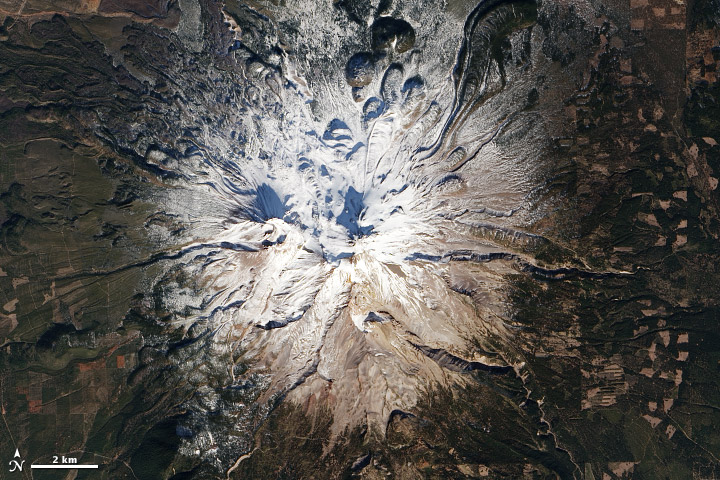
With the aid of afternoon sunlight, satellite photographs provide the same kind of information. In the photographs below, mountain shadows extend from the twin summits of Mount Shasta. The treeless summit is grayish brown, the color of the volcano lava. Tear-drop lobes of slightly different viscous lava stopped halfway down the mountainside and froze into place.
Mt. Shasta, in Northern California, with scant snow cover around March 22, 2014

Image credit: NASA Earth Observatory Satellite, 2014
Heavier snows of the previous winter, accentuate the flow structure of the tear-drop lava masses.
Original Link: http://earthobservatory.nasa.gov/IOTD/view.php?id=82859
While my post is an appreciation of perspective, there are other references at NASA.gov about Mount Shasta and other Cascade Range volcanoes.
While my post is an appreciation of perspective, there are other references at NASA.gov about Mount Shasta and other Cascade Range volcanoes.